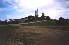
Point Henry today is a far cry from that of the last century. Situated 5 kms from the City of Greater Geelong, on a peninsula jutting out into Corio Bay, it is now mainly recognised as the site of Alcoa Australia's aluminium manufacturing plant. A long pier from the mainland serves ships bringing in the raw materials from which the aluminium is made.
The only sealed road is the Point Henry Road which leaves the Portarlington Road at Moolap and travels between an area of light industries to the right and the saltpans of the former Cheetham solar saltworks to the left.
|
|
The saltpans and swampland area is now incorporated into a Wetlands project, a joint venture between Alcoa Australia and the Department of Conservation and Natural Resources. The former signal station for the Geelong Harbor Trust is now used as the information centre for this project.
Beyond the sealed road, an exposed area of low scrub and sandy beach is utilised by fishermen and paddlers.
Point Henry in the past
Point Henry was first described by Lieutenant Woodriff of the Calcutta in 1803.
the land varies in height and quality, at first low and sandy, then rising from cliffs of Marle to a moderate elevation; a flat of mud and weeds runs off this shore half a mile, which renders landing inconvenient at all times.1
Dr. Alexander Thompson, who became a prominent Geelong settler, shipped his sheep from Launceston to Pt. Henry in May, 1836.
John Sinclair, a member of the Port Phillip Association, was the first to 'own' land in this area, the peninsula being his share. He arrived on the brig 'Henry' in February, 1837, but does not seem to have taken up his allotted land after his two companions, Gellibrand and Hesse, went missing on an overland trek to Melbourne.2
After a visit later the same year by Governor Bourke, Pt. Henry was recommended as the site for a town, but a lack of fresh water made this impossible.3
On the 20th March, 1840, the first shipment of wool left from Pt. Henry bound for London.
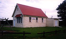
From 1849, there were enough settlers, maybe 20 families, living in the area to necessitate the building of a church and school for the Church of England and a Catholic School. By 1851 there were 56 students at the 2 schools.4
|
|
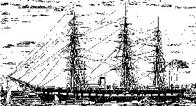
A sandbar across the entrance to Corio Bay meant that in the late 1840s and the early 1850s Pt. Henry became a focal point for shipping. When news of the American gold rushes reached Geelong the miners were looking for transport out to the Californian gold fields, but within a year or so the ships were all carrying miners in to join the rush for gold at Ballarat. On one day during 1854 there were 18 ships anchored off the point.
|
|
Although a small pier had been constructed around 1840 on the east side of the spit, this had since been covered over by sand and shell. The shallow water around the point deemed it necessary for the ships to anchor off shore and the passengers to find their way to dry land as best they could.
From the ships, hundreds of miners joined the tent towns and the slow exodus through Geelong to Ballarat.
After the gold rushes the area became one of small scale farming and in the 1880s the community had only 16 occupiers.5 The school had closed in 1877, the Wesleyan chapel was for sale and by the end of the century the Bellarine Gardens and Hotel, that had existed in one form or another for three decades ceased to attract the crowds which had flocked by ferry from Geelong.
References :
- Ian Wynd, Balla-Wein : A history of the Shire of Bellarine, Shire of Bellarine, Drysdale, 1988, p. 4.
- ibid., p. 113.
- ibid., p. 14.
- ibid., p. 22.
- ibid., p. 98.
[From Jennifer Wright, Member of the Bellarine Historical Society]
Some more notes on Point Henry :-
The early development of Geelong was hampered by a sandbar in the harbour, extending from near Point Henry to the northern foreshore. Only small ships could pass over the bar & larger ships had to discharge their cargo & passengers at Point Henry.
In January 1843 the Geelong Advertiser announced the favourable results of a harbour survey. However, the bar remained a barrier to commercial shipping until a small channel was cut in the 1860’s.
Controversy sometimes remains as to the naming of Point Henry. In the log of the brig “Henry” it is claimed that the point was named after the brig, in June 1836 on their 3rd voyage to Port Phillip, with an alternate claim being that it was named after Lieutenant H. R. Henry of H.M.S. Rattlesnake during surveying of the bay in September 1836. Timewise and from a credibility point of view, the brig "Henry" is the front runner.
[From Noel Lindsay, Member of the Bellarine Historical Society]
Point Henry Arrivals Register
As an aid to family historians the Bellarine Peninsula Historical Society, in 1995, began a register of Point Henry arrivals, covering those who came through the port whether they went to Geelong, Melbourne, Bellarine Peninsula, or the thousands who went straight to the Victorian goldfields. These register forms have been incorporated into our A-Z Family History Files. If you have any information to contribute to this registers, we would appreciate you downloading the Point Henry Arrivals Register form and returning it to us at PO Box 53, Drysdale, Vic 3222. Please feel free to pass on copies of these forms to friends who may also be able to contribute to these worthwhile registers.
Record Sources for Point Henry
- Photographs : Bellarine Historical Society; Geelong Historical Records Centre; various private collections.
- Maps & Plans : Bellarine Historical Society; Geelong Historical Records Centre.
- Newspapers : Geelong Advertiser Indexes - Bellarine Historical Society & Geelong Historical Records Centre; Geelong Advertiser on microfilm - Geelong Historical Records Centre; various local newspapers - Bellarine Historical Society.
- Miscellaneous Documents & Advertisements : Bellarine Historical Society; Geelong Historical Records Centre; various private collections.
- Bellarine Shire Council Records : Geelong Historical Records Centre.
- More recent Council Records : City of Greater Geelong.
- Cemetery Records : (Leopold, Drysdale/Bellarine, Geelong Cemeteries) Bellarine Historical Society; Geelong Historical Records Centre.
- Land Records : Registrar of Titles, Melbourne; Bellarine Historical Society; Geelong Historical Records Centre.
Bibliography
Billot, C. P. The Life of our Years, Lothian Publishing Co. Pty. Ltd., 1969.
Bodsworth, Brian. Point Henry Project, Deakin University Centre for Innovations and Design, May 1993.
Brownhill, Geo. H. Illustrated Guide to Geelong And District, Facsimile edn., Deakin University Press, Geelong, 1990.
Campbell, A. J. Tourist Guide to Geelong and Southern Watering Places, Henry Thacker, Geelong, 1893.
Wynd, Ian. Balla-wein : A history of the Shire of Bellarine, Shire of Bellarine, Drysdale, 1988.
Wynd, Ian. Geelong The Pivot : A Short History of Geelong and District, Cypress Books, Mont Albert North, 1971.


